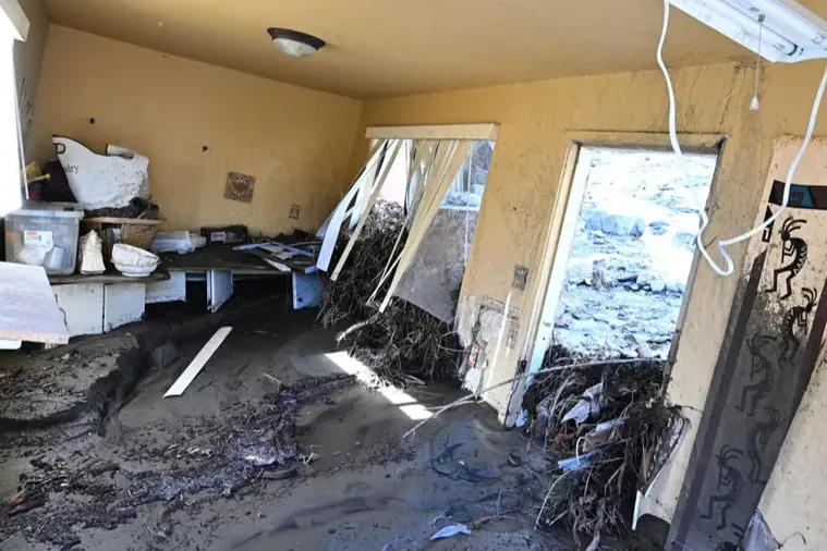
Flood water in a house is a cleanup problem first and a drying problem second. In Safety Harbor, Alligator Creek and Old Tampa Bay are the two bodies of water at the center of the local picture.
Key takeaways
- Alligator Creek flows into Alligator Lake, which discharges into Old Tampa Bay near downtown.
- A new preliminary FEMA map shows roughly 1,390 acres of the watershed in the 100 year floodplain, against about 975 acres on the existing maps.
- The updated study picks up depressions, small lakes and low lying neighborhoods the older maps missed.
- Creek and bay water is Category 3, so wet porous materials come out and the structure is dried with moisture readings.
- Drying continues after the water is gone, and readings decide when it is finished.
Where Alligator Creek water goes
The Alligator Creek Watershed includes parts of unincorporated Pinellas County, Clearwater and Safety Harbor, and it also takes in Moccasin Lake. Its land use is mostly residential.
The channels
Alligator Creek flows mainly west to east into Alligator Lake. A second channel runs from Lake Chautauqua south into the same lake.
Alligator Lake discharges into Old Tampa Bay near downtown Safety Harbor.
The drop in elevation
Land in the watershed runs from about 93 feet in elevation on the northern boundary down to about 4 feet near Alligator Lake by Old Tampa Bay.
Water moves downhill, so it gathers at the low end, near the lake and the bay.
What the new flood map shows
FEMA has released a new preliminary flood map for the Alligator Creek Watershed. The updated study finds roughly 1,390 acres in the 100 year floodplain, compared with about 975 acres on the existing FEMA maps.
The new study includes depressions, small lakes and low lying neighborhoods that the older maps missed. Preliminary means the map is not final.
The city held a Stormwater Master Plan public outreach meeting on March 10, 2026 that showed the current FEMA floodplains and a draft 100 year floodplain.
- A depression is a low spot that fills with rain and holds the water.
- A floodplain map describes where flood water is more likely to go, not what will happen at one address.
- Owners can compare the existing FEMA map with the preliminary one for a given property.
- The city's Building Department gives out flood zone information.
Erosion, storms and the waterfront
A U.S. Army Corps of Engineers Jacksonville District fact sheet for the city says normal and storm related water flow through the creeks has caused significant property erosion.
Flood water covered Waterfront Park next to the pier after Hurricane Idalia on August 30, 2023.
Mullet Creek runs under the Waterfront Park boardwalk, and the section over the creek that closed after 2024 storm damage reopened on March 18, 2026.
Erosion and flood water are different problems, but a home near a creek can face both. Soil that washes away changes how water moves across a lot, and a wet yard can become a wet floor.
Cleanup when creek or bay water gets in
Water from a creek or a bay has crossed ground, ditches and yards before it reaches a house. That makes it Category 3, and the cleanup treats it that way.
A full flood water cleanup starts with extraction, then removes wet carpet, pad, lower drywall and insulation.
Hard surfaces are cleaned and treated, and the wider flood water cleanup work follows the same order from the first pump to the last reading.
Creek water can also leave silt in wall cavities and under flooring. Opening the cavity lets the team remove silt as well as water.
- Standing water is pulled out with truck mounted and portable units.
- Porous materials that soaked up the water are removed.
- Wall cavities are opened where water wicked upward.
- Surfaces that stay are cleaned and treated before drying starts.

Drying after the water is gone
Removing the water does not make the structure dry. Framing, block and flooring hold moisture and let it go slowly.
Structural drying puts air movers and dehumidifiers in the affected rooms and checks moisture readings each day. The equipment comes out when the readings reach the dry goal.
Wet framing and block take the longest. The bottom of the walls and the wall cavities are checked first, because that is where moisture hides.
Mold can start to grow on wet materials within 24 to 48 hours, so drying begins as soon as the water is out.
- Air movers push dry air across wet surfaces.
- Dehumidifiers pull the moisture out of the air so the walls can release more.
- Daily readings show which rooms are ready and which still need time.
First steps for a wet home near the creek or the bay
Local water damage restoration teams ask for the same few things at the start of a flood job.
- Shut off power to wet areas at the panel if it can be done safely.
- Stay out of standing water and keep kids and pets away from it.
- Photograph the high water mark on walls, furniture and contents before moving them.
- Lift small items and papers onto dry surfaces.
- Write down which rooms were wet and when the water was found.
Using the map and the records together
A floodplain map and a set of drying records answer different questions. The map says where water is more likely to go, and the records say what the water actually did inside one house.
Owners who keep both are better prepared to talk with a builder or a lender about repairs.
- Look up the property on the current FEMA maps and note the zone the city gives out.
- Keep photos and moisture readings from the cleanup in one folder.
- Watch for the final version of the map, because a preliminary map can change.
- Ask the drying team for the final moisture readings when the equipment leaves.
Questions
Does a new flood map mean a house will flood?
No. A floodplain map describes where flood water is more likely to go. It does not predict what will happen at one address, and the new map is preliminary.
Is creek flood water contaminated?
Yes. Creek and bay water pick up soil and bacteria as they cross ground, so the cleanup treats them as Category 3 and removes porous materials that soaked them up.
How long does drying take after flood water?
It depends on the materials and how long the water stood. Framing, block and flooring dry slowly, and daily moisture readings decide when the equipment can come out.
Why is drywall cut above the water mark?
Drywall pulls water upward past the visible mark. Cutting higher lets the team reach wet insulation and framing and dry the cavity properly.
Where can an owner find flood zone information?
The city's Building Department gives out flood zone information.
What does preliminary mean for a flood map?
Preliminary means the map has been released but is not yet adopted. It can change before it takes effect, so the existing maps and the draft both matter in the meantime.